

Some photographic locations can be reached with a short walk from the car park. Others require hours of climbing, careful planning, and a willingness to carry everything you need into the backcountry. In this issue, Peter Laurenson takes us into the rugged alpine landscapes of Kahurangi National Park in search of a remote tarn near Mt Lockett, a journey that delivers spectacular scenery, unexpected challenges, and a reminder that adventure photography rarely goes exactly to plan. From lake-studded ridges and peaceful camps high above the valleys to an unfortunate encounter between a camera and a river crossing, Peter’s story captures both the rewards and realities of photographing New Zealand’s wild places.
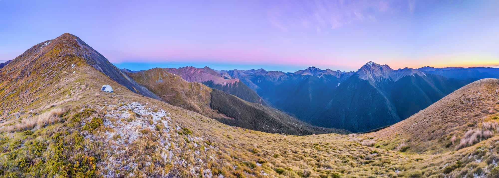
One of the challenges of ridge travel in the often karst-based Kahurangi is water supply, especially in summer months. The limestone and marble can be cracked and porous, allowing the relentless trickle of water to drill sink holes through it over geological time. When you climb up through the forest above the many rivers in the region, if you haven’t carried it with you, the main water sources on or near the ridge tops above are tarns, and these can be few and far between in places. While browsing the NZ Topo map a marked tarn just beneath the summit of Mt Lockett caught my eye. There is a frequently used camping spot beside Lockett Lake, but having such a conveniently located tarn so close to a summit was enticing indeed. So in April I went for a look.
The access to Lockett Lake and the Lockett Range is up the spectacular Cobb Dam Road, off SH60 near Upper Tākaka. The road traces Tākaka River through towering vertical cliffs and dense near-vertical forest to Cobb Power Station, then on up to Cobb Reservoir. At the dammed northern end is a car park at the trail end of the Sylvester Lakes Track and also a lesser travelled trail, forged by the Friends of Cobb conservation group, extending from a quarry, up beside Diamond Lake Stream to Lake Lockett. My plan was to use this trail to reach the lake, then find a way up to the bush line above to access the Lockett Range, proceed along those tops to camp near Mt Lockett’s 1621-metre summit, then next morning drop 300 metres to the valley containing Diamond Lake, before climbing up the far side of the valley to the ridge leading to 1695-metre Iron Hill. From there is a well trodden trail leading down past Lake Sylvester to my parked car. While this route is about 28km and requires nearly 2000 metres of ascent (some sweat required), it’s not particularly difficult tramping and the lake-bejewelled alpine landscapes are certainly worth the effort – especially when camping where I did to enjoy the magic hours, abundant water supply and calm solitude up high.
My plan went almost without a hitch. Almost. On my way in I had to cross Diamond Lake Stream just once. The river crossing isn’t difficult, but I was wearing some new tramping boots on their maiden voyage. Their vibram soles proved to be slippery on wet rocks. I’d taken care to avoid getting my boots wet as I rock-stepped my way across. With only one more step to reach the far bank my head, shoulder and chest, where my new Sony RX100VII camera sat awaiting use in its little pouch, suddenly were submerged. Not good. I quickly clambered out while uttering many not publishable expletives. Despite giving Sony some electronic CPR it could not be revived (at time of writing one month later I have just received my now fully recovered Sony back from the doctors, along with a $540 repair bill). What to do?


